Having walked the Maidenhead Boundary Walk several times over the years, and having seen the marking on the route map of these “stones” along the way, marking the original boundary, my interest was sparked to find out more about these boundary stones, and to try and bring together all of the details and history of them into one place. I hope you enjoy reading…
If you do have any updates or other information on these stones or their history which we could include, or just plain interested, please do get in touch with us!
I have collated data from many online sources, Maidenhead Advertiser, Maidenhead Civic Society to name a few, as well as walking the route and photographing where the remaining stones are located. Its good to see that a good number of them still remain today almost 90 years on, and the hope is that they are still all there in 2034 for the 100 year anniversary!
History of the Boundary Walk
On 7th March 1582 a ‘Charter of Incorporation’ was granted to create the Royal Borough of Maidenhead. It was a tradition for the Mayor of Maidenhead to get beaters to drive in squared-headed nails to posts and walls along the boundary route, each nail with the Mayor’s initials on the nail head. The image below shows some boundary nails which are still in tact, although no longer able to see any initials inscribed.

Walking the boundaries at Rogantide has a religious significance. Beating boundary stones is intended to frighten any evil away spirits from the town.
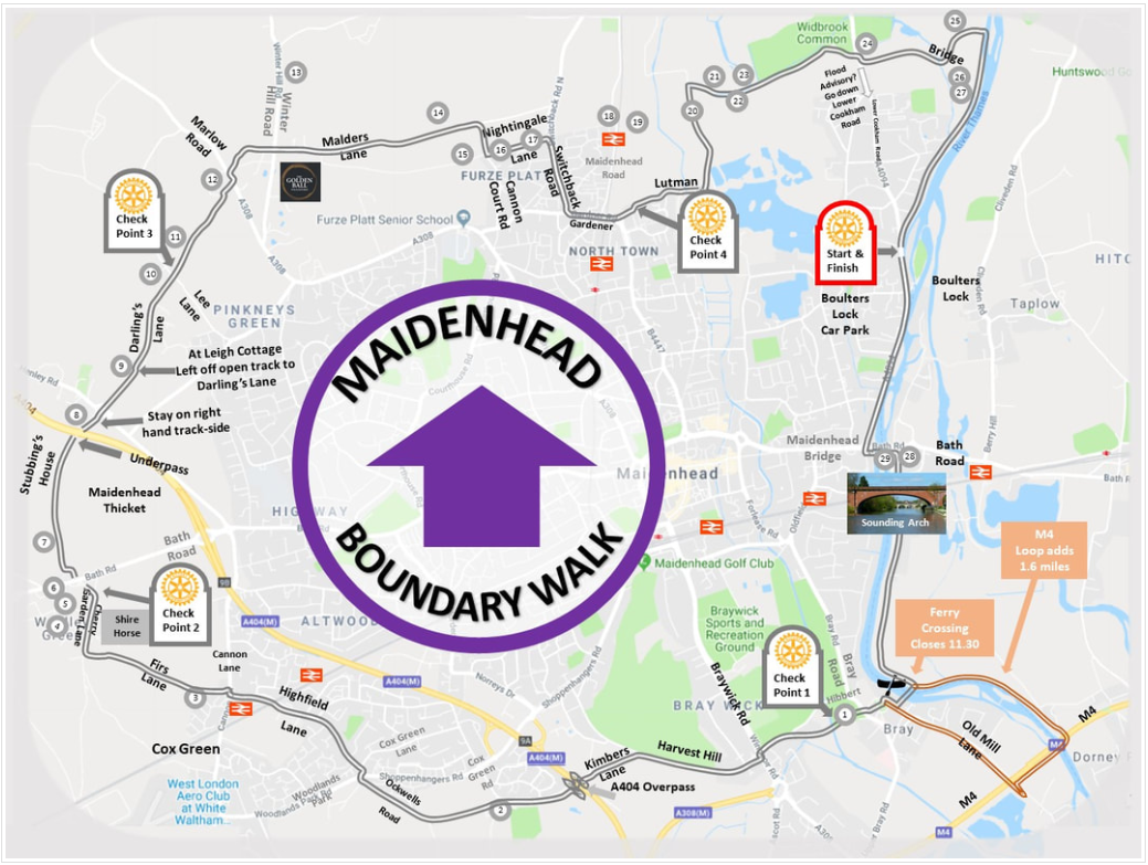
Below is the map from Maidenhead Rotary showing the route and also note they include boundary stone numbers and locations. It has been noted that BS 2 is shown in the wrong place and has been for many years! (it should be further down the road at the junction of Woodlands Park Road) Its very possible that this map was simply re-produced from another map where the locations were already wrong. It is also true that this stone was not observed on the 1949 or 1973 perambulations!
Beating the Bounds has roots back to Europe in the early ages.
It was initiated by the Archbishop of Vienna in the year 470 after terrible plagues and minor earthquakes had caused much hard ship among the people. He ordered special prayers, asking God’s blessing on their crops, to be recited as the villagers processed around their fields. The custom spread rapidly around Western Europe, and by the eighth century was established in Britain. In days that offered little excitement to ordinary people, it can be imagined that processions around the countryside in lovely spring weather were very popular. In fact, not only the fields were blessed; in seaside districts the parishioners would troop down to the waterside and less the water and the fishing boats and pray for a good fishing season ahead. These processions were also useful in showing people their parish boundaries and as time went on, these boundaries became even more important as administration was changing. So, the custom of ‘beating the bounds’ grew up to show everyone, and especially the younger members of the parish, where the boundaries lay. At the boundary-marks of the parish, such as a pond, a big tree or a rock, the parson would stop and read the Gospel, and when this had been done the boys of the parish suffered some indignity to imprint the boundary-mark on their minds. Sometimes they were bumped about.
During the old 1835 walk, the Mayor would tap each stone with their mace to confirm the boundary.
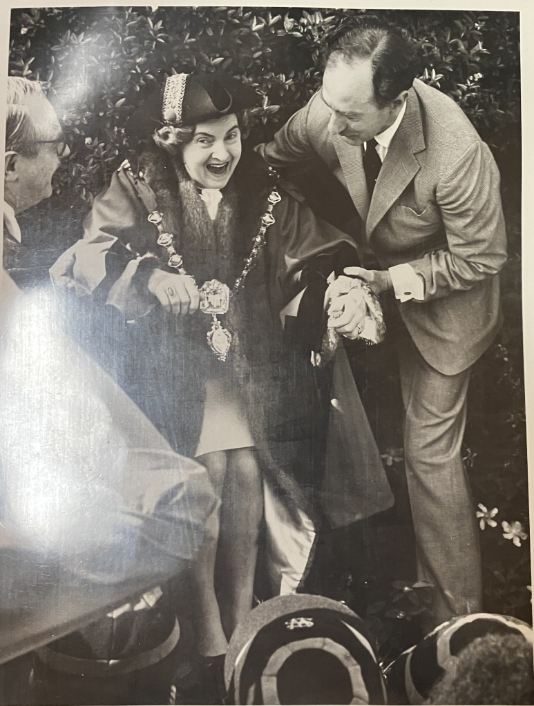
The last official ‘Beating the Bounds’ ceremony in Maidenhead was held July 1973, when Euphemia Underhill was the Mayor. It was recorded that during the walk there were moments of light-hearted fun and laughter, and both the dignitaries and the townsfolk who took part ran the risk of being grabbed and bumped on the boundary stones, and if the victim was a female, she would expect to be kissed. Amazing to think this would not be allowed today! After 1973 the tradition of beating the bounds and walking around the boundary each year died out until it was resurrected in 1982.
Since 1981 the Rotary Group of Maidenhead has run the boundary walk as an annual charity event on the first Sunday in October. However, this current project is more about promoting the walk as a regular facility to be used by locals rather than actually beating the bounds or being bumped!
Beating the Bounds
‘Beating the Bounds’ or ‘perambulating the bounds’ is an ancient tradition which traditionally involved swatting or ‘beating’ local landmarks with usually birch or willow green boughs to mark out the limits of the parish boundary, and to ensure the local folk have a precise memory of the location of these boundaries.
The origins of Beating the Bounds are deep in past history, usually taking 2 days in more recent years to carry out this ancient ceremony. Usually happy days for those taking part with many moments of light-hearted fun. Those taking part in the proceedings ran the risk of being grabbed and bumped on the boundary stones, and if the person being bumped were a lady she ran the risk of also being kissed, regardless of whether they were a child or a dignitary.
Aside from the bumping’s and kissing’s, the ceremonial procession was led by the Mayor wearing the chain of office, escorted by a police sergeant and constable carrying the Bridgemaster Staffs of 1667 and Mace Bearer carrying the smaller edition of the town mace dating back to 1604. School children who had been chosen to represent their schools were also part of the procession, carrying white pennants with ‘MB’ in blue letters on the ends of slender canes, and each was rewarded by the Mayor at the end of the day with a newly minted sixpence.
Before the start of the procession the Mayor would address the party to explain the ceremony and to refresh those in attendance of the boundaries of the borough, and in particular to ensure the young people were aware of where the boundaries lay. During the perambulation, the mace was tapped at each official boundary marker and the beaters were invited to drive nails into posts and walls as a symbol of where the boundary was. The nails were around 2-3cm square and bore the initials of the Mayor and the year.
There were several reasons for marking out the boundary.
- To ensure that neighbours did not encroach on land that was not theirs
- To ensure matter such as liability to contribute to the upkeep of the church or the right to be buried in a churchyard could not be disputed
Very often young boys were taken along to ensure longevity of memory of the boundary, and sometimes they were whipped or violently bumped on the boundary stones as a way to make them remember!
I hereby give notice that pursuant to the Charters of Queen Elizabeth I, James I, Charles II and James II and following custom faithfully observed since those times, the boundary of the Borough of Maidenhead in the Royal County of Berkshire will be perambulated by the Corporation of the said Borough and others, on Monday the 9th July and Tuesday, the 10th July, 1973, beginning on the first day at 9.40 a.m on Hibbert Road, Braywick, when and where all persons interested may attend if they think proper.
Dated this 28th day of June, 1973
Stanley Pratt, Town Clerk
Beating the Bounds around Maidenhead, published by the East Berks Ramblers’ Association. 1982
During the last 100 years, these are the years when the Bounds were beaten around Maidenhead several times: 1874, 1878, 1891, 1901, 1909, 1920, 1934, 1949, 1963 and 1973.
Below image from Maidenhead Advertiser from 1932 shows the then current boundary and the proposed boundary which would then last up until 1973.

The image below from the Maidenhead Advertiser of 28th December 1934, makes reference to the new extension of the boundary:

There are certainly 2 famous ‘perambulations’ of the boundary recorded in 1949 and in 1973. The following is from the Maidenhead Advertiser, July 13th 1973. (The recorded beating of the bounds was held on 9th and 10th July, and reported in the Advertiser on the 13th July).
Last ever beating the the borough boundary was a jolly affair. Lots of kissing and laughter, lots of blazing hot sun.
Maidonians, led by mace bearer and mayor, have beaten the bounds since 1582, ostensibly to remind adults and instruct youngsters on the line of their borough.
Monday and Tuesday’s beat, only the fourth since 1909, was the last because next year the borough will be merged into District 4.
The Mayor (Cclr Mrs. Euphemia Underhill), clad in fur-trimmed red robes, chain of office and high heeled black boots, took the first bumping in Hibbert Rd, Braywick.
There were 28 boundary stones, on which one or more of the 80-strong party was bumped (and if female, kissed), plus 22 points where boundary nails with the Mayor’s initials “ERU” were hammered into trees and outlying posts.
First bumpings over, Mrs Underhill changed her shoes, took off her robe, and the group stepped briskly off up Harvest Hill. The sun shone, amazed bullocks bucked and wheeled in an adjoining field, and everyone thought what fun.
It was an altogether quieter bunch that offered thanks when the Thatched Cottage at Cox Green hove into view. “At last, a waterhole” one man cried.
After lunch at the Coach & Horses by the Bath Road we all felt better again. Laughter was happy when a newly bumped policeman said to a burly councillor “I won’t kiss you.”
But by the end of the first day, after around six hours walking, the party was silent. Bumping was hasty, feet sore. And the sun shone on.
Walkers included local dignitaries, a handful of nimble pensioners (who fared much better than us car-spoiled young) and Cclt Fred Allgood, who had flown in from Paris specially for the occasion. “All great fun,” was his verdict.
Tuesday’s section included a march from Nightingale Lane to the Thames, a trip down river, and lunch at Skindles.
Total distance-covered on foot was nearly 11 miles. Wisest beaters wore hiking boots and safari kits. The deserving were given 1970 shillings in memory of the occasion.
Maidenhead Advertiser, July 14th 1973

Boundary Stones of 1934
Boundary Stones were placed around the Borough in 1934 to mark the exact boundary; the stones were inscribed with ‘MB’ signifying ‘Maidenhead Borough’ and the year. The stones were purchased for £18, a whole 7/6d each! The Maidenhead Advertiser of April 4th 1934 records:
Borough Extension : Boundary Stones
Maidenhead Advertiser, April 4th 1934
“The quotation of Messrs. Johnson Bros., of London, for the supply of four dozen “Cornolith” Boundary Stones at a cost of £18 has been accepted”
Over the years there have been many variations of maps and numbers of stones found, and you can see already there is a reasonable amount of doubt about how many stones were remaining in each year. Some may have been missed or simply not accessible. Some of the stones will have disappeared into the undergrowth, been relocated, dug up due to roadworks or become impossible to view with changes to permissions where one is permitted to walk, such as those at Woolley Firs and Battlemead Common / White Place Farm.
On page 14 of this newsletter from Autumn 2007, from Taplow Hitcham and Taplow Preservation Society records that:
“in 1949 only 27 stones out of the original 48 were found”
Beating the Bound around Maidenhead states there were 27 stones visited during the 1973 perambulation, although the Maidenhead Advertiser reports that it was 28!
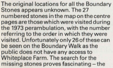

The Environment Agency states that in 1993, only 29 stones remained, and yet the Taplow Hitcham and Taplow Preservation Society records that only 27 remained in 1949!
This lovely map produced by Michael Bayley in 1982 records 29 locations. Most of the boundary stone numbers shown on this map have been continued to be used today, and any new stones discovered, continue the numbering from 28 upwards.

We have recorded the locations of the stones that we have actually seen in 2024 onto this public Google map, and we are up to 30!
If you click on the map you can expand to view in full screen using the [ ] option in top right. Each of the blue numbered icons indicate the boundary stone numbers and clicking on the icon will reveal some pictures and a brief description of where the stone is located. Much more details on the locations of all of the stones will be provided in a later post.
Please have a read of our next post which shows the locations of where the remaining stones have been found – there may yet still be more out there!
